The Engineer’s Art
Surveying the origins of the French cartographic imagination
By Tom Conley
Before I had to return to the United States at the outbreak of coronavirus, the research I pursued in the Helmut Kohl Study of the fellows’ pavilion and from the little terrace of apartment 4, looking south onto a stunning view of the Wannsee, is of two orders: it begins from anthropologist Claude Lévi-Strauss’ reflections on tricksters in Amerindian mythology, who scurry through four volumes of Mythologiques (1962-71), whom the anthropologist had earlier tied to a broadly based concept of the bricoleur, an engineer of mythic matter. Borrowed from the world of engineers and engineering, from sport to combat, “ricochet” to rebound, bricolage today is affiliated with tinkering, slapping together, DIY of the kind shown in home-improvement YouTube videos and in Popular Science magazine.
Lévi-Strauss aimed to show how the bricoleur’s labors, ongoing and open-ended, stand in contrast to the engineer’s programs that deploy all means possible to obtain their desired results. For the historian of cartography, bricoleur might designate an “amateur”—like Balzac’s flaneurs (without a Flaubertian circumflex over the ‘a’), who flip through sheet-maps and atlases to observe and examine worlds within and beyond their ken. The amateur would let a spatial imagination take command when they configure virtual itineraries to places unknown. Their imagination would lead them, as Baudelaire later penned in English in a dystopic vein in his Poèmes en prose, to places “anywhere out of this world.”
The engineer would be of a different ilk. A topographer who masters the art of perspective, a logistician; he is surveyor of considerable rank-and-file assigned to survey, map, and redesign defensive structures at the nation’s borders. For a military historian such as David Buisseret, the late fifteenth and early sixteenth centuries witnessed the appearance in Italy of specialists who mastered methods of “defending towns and strongpoints with a system of interlocking walls and bastions so as to resist the newly powerful artillery.” Following the Franco-Italian wars of Louis XII and Francis I (1494-1559), under the aegis of the French king Henry IV, they were of an echelon “much the same as that of contemporary architectes, géographes, mathématiciens, and topographes.” Their role extended to projects of broad scope, including redesign of fortresses and even the realization of the Canal du Midi, an extensive waterway that opened passage from the Mediterranean to the Bay of Biscaye.
The engineer is related to the Latin ingenium, to ingenious ways of thinking and working. In the first great French-English dictionary (1611), lexicographer Randle Cotgrave is quick to note:
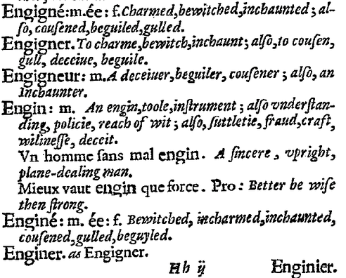
If the catchword “enginier” designates a past master of “suttletie, fraud, craft, wiliness, deceit,” he or she is related to “Coyote,” the fabled trickster in myth, or to Hermes or to the poet, for whom “truth” is an illusion or an unrecognized error, even a lure and a lie. It may be in the same spirit that in the opening pages of René Descartes’ Discourse on Method, a preface to a treatise on optical aberration and anamorphosis (1637, published anonymously in Holland), that the unnamed author wonders if some “evil genius” is fooling him while he writes. Descartes (whose very name speaks volumes about his taste for mapping) invokes a “daimon” or an “other” who splits and deceives him as he pursues “truth.” Ingenuous, genial, crafty and cunning, Descartes’s malin génie (less an evil genius than an inventive soul) is fancied tricking the philosopher who imagines himself fraying his way to clear and distinct ideas. In winter and in northern climes, he warms himself by his poele, a Dutch stove. He fashions his persona through bilingual writing in which Latin seeps through the French, and vice-versa. Contending that he is drawing, depicting, painting a tableau, he crafts both a picture and a spiritual autobiography. From its very first sentence, the Discourse informs the reader it is designed as an itinerary: because “le bon sens est la chose la mieux partagée du monde” (good sense [or direction, orientation] is the thing best shared in the world). In the second chapter of the same work, he would wish himself to be an engineer specialized in urban planning:
Thus, these older cities, at the beginning nothing more than little towns, over succession of time have become great cities, are ordinarily so poorly drawn that at the cost of these regular places that an Engineer draws in his fancy on a plain, that yet in considering each of their individual buildings we can often find as much or more art than those of others; in every event, seeing how they are arranged—here one large, there one small, and how they render the streets bending and uneven, we might say that, rather than reason, or the will of a few men using reason, fortune has disposed them to be as they are.
Descartes’ Discourse appears at the end of a larger project whose itinerary begins in Ingolstadt and Leipzig, where Pieter Apian (1495-1552), a famed astronomer and cosmographer, published his Cosmographicus liber (1524). The manual was soon translated into Dutch, French, and Spanish and would be published in thirty editions over the next 75 years. Revised in the 1540s by the Dutch mathematician Gemma Frisius, the book included chapters on practical geometry, the art of survey, and—with inclusion of Amerigo Vespucci’s four missives about the continent he baptized with a feminine rendering of his Christian name—information pertaining to the New Discoveries. Equipped with polar projections, diagrams, and (as of 1543) a truncated cordiform wind-map of the world, the Cosmographia can be appreciated as a manual of spatial reason and as a diptych juxtaposing a panel devoted to humanistic geography with another that deals with practical mensuration—in other words, engineering. On one side, an armchair tradition is drawn from the Geographia; on the other, added by Frisius, supplemental material depicts how cartographic survey operates by way of trigonometry and on-site examination of places and the structures that mark them.
The ingenuity of Apian’s labors are resonant in his moniker. Born with the surname Biennevitz, in Saxony, he altered his given Biene, or “bee,” into its Latin analogue into a totem of the virtual topographer, who buzzes from flower to flower, who forages and surveys the local terrain, gathering what he needs to process in the hive of his studio. Through mastery of practical mathematics that yielded a prototype of Pascal’s triangle and a table of sines, Apian provided for generations the means and methods the engineer puts to use in the art of mensuration.
Two of the diagrams in the Cosmographia indicate how and where measure and subjectivity coincide. In the most famous similitude, in line with the first sentence of Claudius Ptolemy’s Geographia that likens cosmography to the painted portrait of a sitter’s face and topography (chorography), Apian offers an enduring visual homology. In a manuscript copy held in the Universitätsbibliothek Erlanger-Nürnberg, two flesh-colored images describe the problematic relation that local space holds with the world at large (fig. 1).[1]
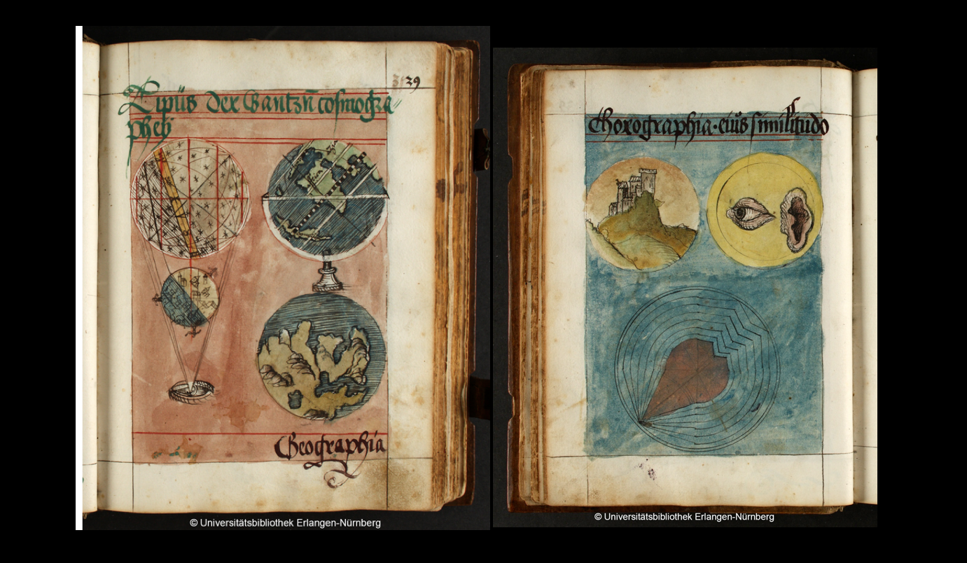
On one folio (39r°), two two-part diagrams comprise a quadrangular unit. At the bottom left, an isolated eye projects (or emits, if its gaze is extramissive) lines of vision that include in their purview, first, a terrestrial sphere on whose extrados three stick figure are ambling, two by night and one by day. Beyond, a celestial sphere is studded with stars in a firmament bound by a zodiacal band. Resembling Montgolfière’s hot-air balloon of 1783, the diagram moves upward, from an isolated eye to the greater cosmos. To the right, two globes (one on a swivel and a stand) are set over each other. The upper sphere (whose divisions follow the lines of a prototypically Macrobian zonal map) includes Europe, Africa, and the Near East to the right of a long and narrow island of the Americas (perhaps inspired by Martin Waldseemüller’s world map of 1508, which now hangs in the Library of Congress). Below, and over “Geographia,” a world map (the south pole at its apex) displays Europe, Asia, and Africa. The similitude is completed on the verso side, where a background in delicate blue wash surrounds two spheres, the one including a city-view and the other, an isolated eye and ear. A diagram on the bottom fills out the page.
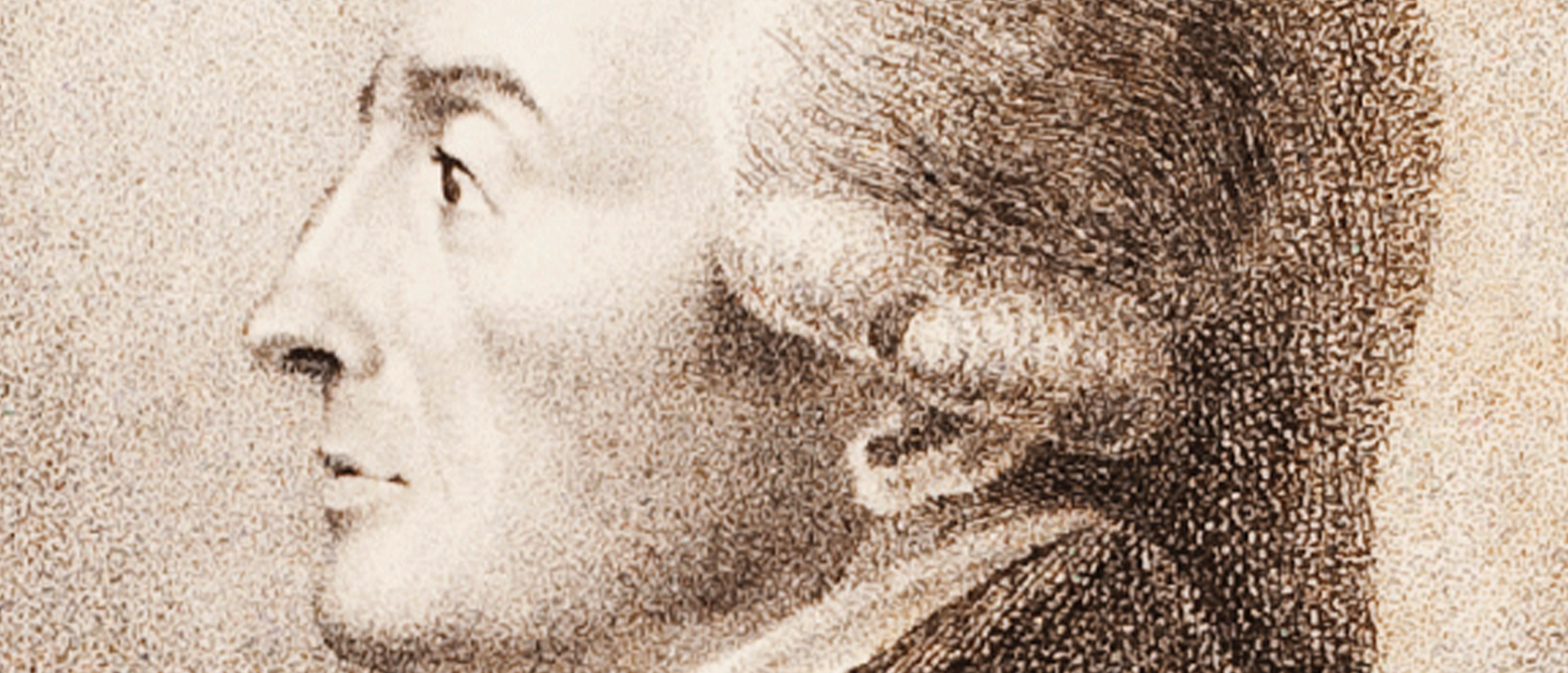
The printed editions of the Cosmographia—all thirty of them—are more clearly drawn. In the Paris edition (Vivant Gaultherot, 1551 and 1553, respectively, in Latin and French) the portrait on the upper right displays a sitter, shown in profile, of a physiognomy bearing uncanny resemblance to imago Christi (fig.2. Click on low-resolution image below for high resolution, detailed image).
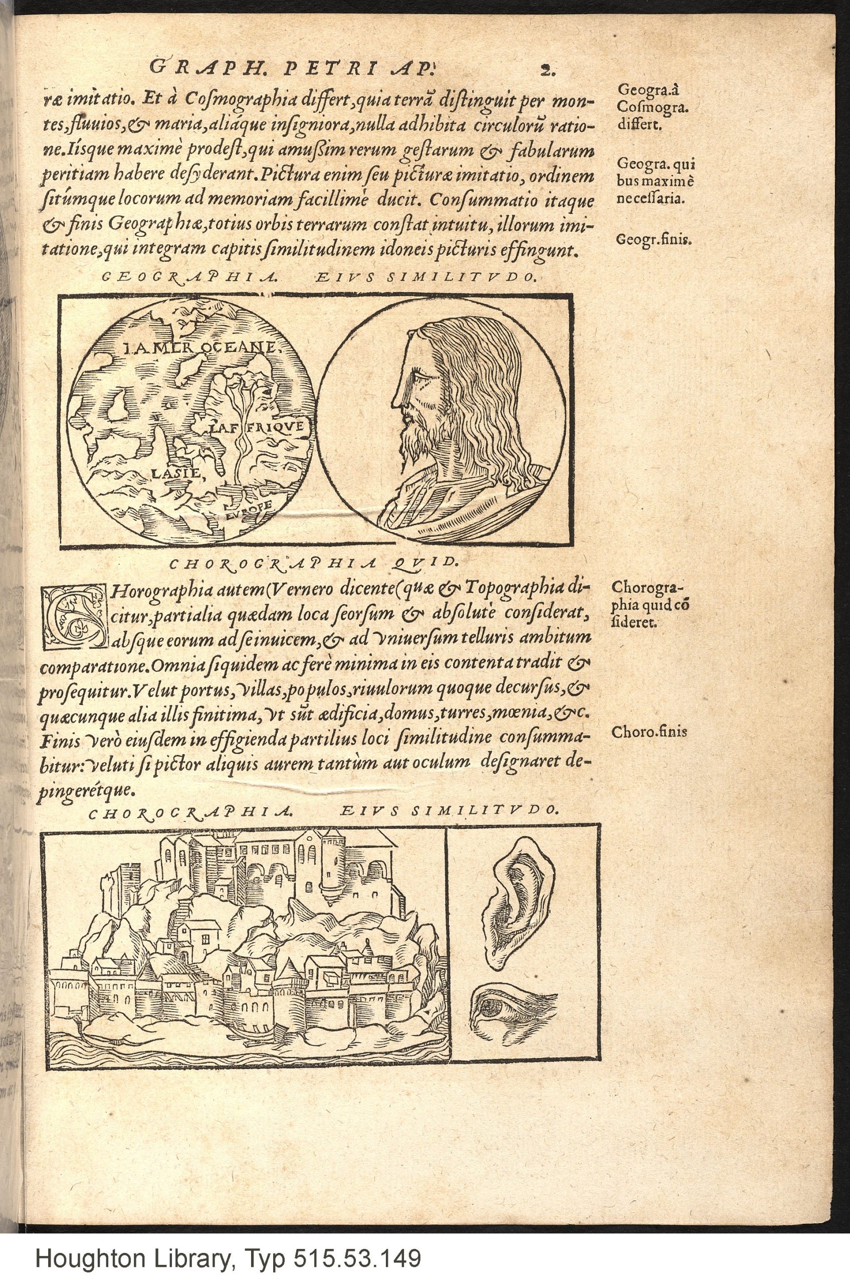
Taken from an Italian medallion, enclosed in a tondo, this “personification” of geography looks across the page at an imago mundi, facing the viewer, that he would be unable to see. Also enclosed in a circle, the worldview on the left includes the three known continents (Asia, Europe, Africa) and a hypothetical land (reported by Magellan’s crew in his 1523 circumnavigation), Antarctica. Enhanced by fine parallel hatching, the continents and islands (including the fabled Taprobana, in the middle left, an avatar of Sri-Lanka) seem to float on the “ocean sea” or ecoumene that in earlier T-O maps (e.g., Augsburg, 1473) had defined the perimeter of the known world. Dominating the illustration, the Nile and its sources suggest that the River is rich in history and fantasy, perhaps even referring to Prester John, the mythic Christian who had been said to live in Abyssinia. Two moments of duration are juxtaposed, the one of time with neither beginning nor end, the other of human proportion, defined by birth and death. The pairing suggests that Christ, who would be creator of the world, contemplates his creation—or considers it as might a surveyor.
Below, where “Chorographia” is compared to a city-view—an agglomeration of buildings on an island adrift in a greater sea—a basilica or monastery is planted atop a vertiginous landscape where, below, encircling the lower area, a town is served by a dinghy resting on the ground at what might be low tide. Chorography thus deals with areas detached, literally isolated from a continental mass, without connection to a greater—and in this image, visually indiscernible—whole. To the lower right, like the city-view, the eye that would behold its analogue and the ear that might hear a voice of “presence” is detached from whatever body or bodies they have been taken. The fine hatching of the auricular orifice suggests that its cavernous region might be a spelunker’s paradise, while the pupil of the eye is depicted in the style of a polar projection by circular hatching resembling lines of latitude and straight lines that appear as meridians of longitude (fig. 3).
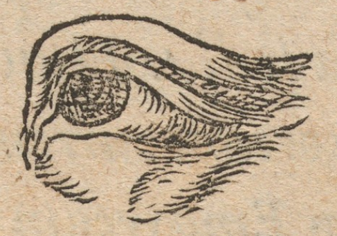
The quadrangular similitude suggests that, like the figure of Christ in profile who stares at a world he cannot see, the portrayed eye and ear have little to do with the floating agglomeration to which they are compared. Given to study the ambient world, the pupil representing chorography would be perhaps anticipate that of the surveyor and engineer. The implication of the relation of world-and-detail shown at the beginning of the Cosmographia is especially manifest in the chapter describing how a topographical map can be made (fig. 4).
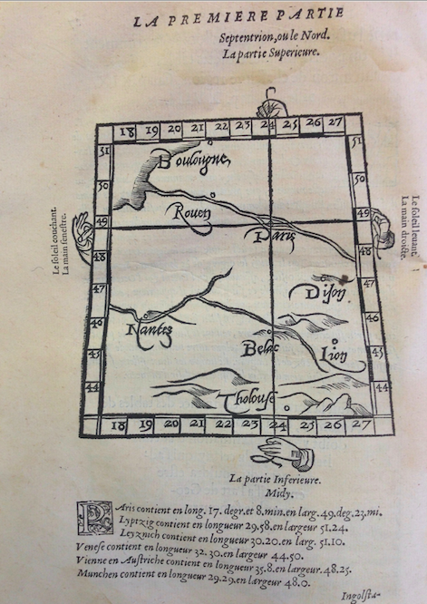
Following Ptolemy’s method, Apian begins with two taut strings, held by hands detached from their bodies, which cross at a perpendicular angle. From the point of their intersection, the horizontal string serves as a baseline for latitude, and its vertical complement for that of longitude. From the intersection, degrees or “climes” are marked off to form a grid. In editions printed in Antwerp and northern Europe, the axial point of origin is Apian’s own homeland or birthplace, Leipzig or Ingolstadt. In a copy held in Yale’s Beinecke Library, Prague is the point of departure, while the Paris editions, as expected, begin in Paris, but with passing reference to Ingolstadt. No matter what may be its point of origin, the method of the map tilts its association with Ptolemy’s “humanistic” cartography toward greater practical orientation.
This practical orientation is found in the supplemental material Gemma Frisius brings to the later editions of the Cosmographia, in chapters that take up mensuration and engineering. Surveyors are seen going into the field, calculating distances between sighting points and places. Topographers all, armed with theodolites and astrolabes, standing alongside moats, at the foot of walled structures, or knocking bats out of belfries, by virtue of experiment they become expert in spatial reasoning and, no doubt, they stand strong as prototypical engineers (fig. 5).

Now and again, they populate the maps they produce. An arresting avatar of the figures Apian portrays in the pages on descriptions of sites is found in a precocious topographical map of Auvergne (1560), which antiquarian Gabriele Symeoni drew for the Bishop of Clermont-Ferrand (fig. 6. Click on low-resolution image below for high resolution, detailed image).
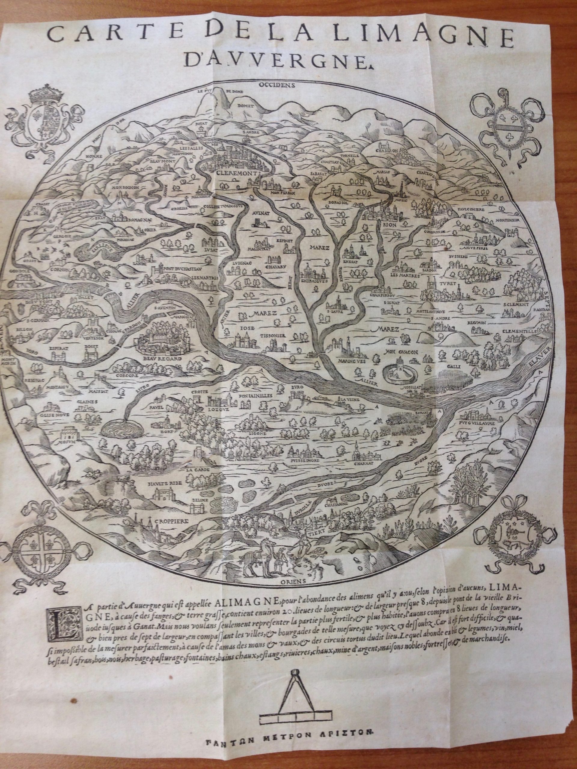
In this projection, on cursory glance a splendid work of potamography (the mapping of rivers), the course of the Allier branches through the massif central before it empties into the Loire (beyond the frame) to the right. A double perspective displays the sloping terrain as it descends from the Puy-de-Dôme (where Blaise Pascal discovered the principle of the vacuum) to Clermont below, then to the flatter landscape that extends below a promontory on which stands a surveyor who holds high in his right hand a pair of dividers. At his feet are strewn some papers, a theodolite, and some writing instruments, and behind him an assistant holds by the reins a sturdy workhorse.
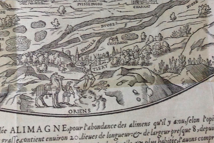
From within the map he has produced surveyor looks over the landscape he is making. His actions (and his paraphernalia) display how the map is “engineered.” Unlike many sheets in atlases of the century to follow, in which the authority of the projection is enhanced when its mode of production is hidden, the process by which it is drawn becomes part and parcel of a greater narrative touching on its ideology. At the cleft of the juncture where the River Duore (lower right) flows into the Allier, and near the shore just above, soldiers are depicted readying for battle, which in fact seem to be what the minuscule surveyor at the bottom is considering. The legend below is indicative:
[The part of Auvergne that is called Alimagne [is known] for its abundance of aliments: or, according to some opinions, Limagne, because of muck and rich soil, is contained in an area about 20 leagues [60 miles] in length and almost 8 [24 miles] in width, extending from the Briode bridge as far as Ganat. Because we wish only to represent the most fertile and most densely populated portion, we have limited [the map to] 8 leagues in length, and just about seven in width, encompassing the cities and townships of the scale that you see below, and it is almost impossible to measure it perfectly because of the clusters of hills and valleys, and tortuous roads of the given place. Which abounds in wheat and vegetables, wine, honey, cattle, saffran, woods, nuts, grasslands, pasturage, fountains, mineral baths, ponds, rivers, lime, silver mines, noble abodes, fortresses, and merchandise.]
Reconstructing the battle between Vercingétorix and Julius Caesar, the text that accompanies the map follows its stages of conflict in the interest of producing the beginning of a history of a national consciousness. Thus, we see on either side of the confluence of the Rivers Allier and Duore, adjacent to the Puy Guillaume, their tightly bunched spears, erect like stalks of wheat, the soldiers preparing for war. On the far side, the Galli prepare to engage the Romani on the other side. An archaeology, the map invites the viewer to “speculate” on the past and present condition of the area shown. The text that follows, a dialogue between a teacher and a student, written from a fiercely French (or Gallic) point of view, a didactic tour de force, rewrites a moment of history recounted in Caesar’s Commentaries. Looking at the area from the point of view of the surveyor who is preparing the map, the viewer beholds a greater landscape studded with toponyms and miniature city- and town-views attesting to the distribution of the population, areas of forest vital for industry, the resources of the rivers for travel and commerce, and no less crucially (although the postal roads are not shown), bridges erected at strategic places. In turn, as the legend makes clear, the map contains an implicit panegyric describing the wealth of the area. It would not be wrong to say that the map is a work of both bricolage and of engineering.
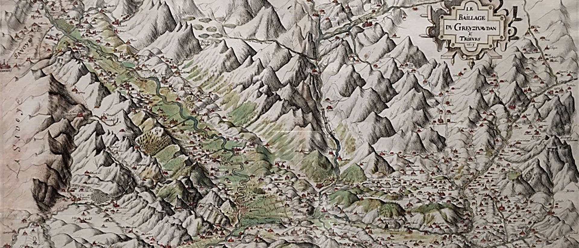
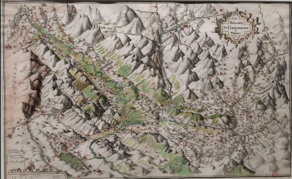
The proximity of the engineer and the artist is clearly shown in the legacy of the ingénieurs du roi who implement technologies of observation and the craft of description. When seen and read as such, they play a significant role in the history of the emergence of landscape and the ways by which it can be seen and read. It suffices to glance at the drawings of Jean de Beins (1577-1651), an artist–soldier–engineer who carried a harquebus (a form of long gun) to battle at age 13, fought for the Protestant cause, was often wounded in the waning years of the Wars of Religion (1562-1598), and who later became a major figure in Henry IV’s program to shore up and redesign the fortifications of France. For the mountainous Dauphiné, he drew numerous maps, 75 of which are held in the British Library, which attest, as historian of cartography François de Dainville noted, to the talents of an artist. His description of the Bailiwick [Baillage] of Greyzivautian and Trieves (1619) invites the reader to travel along valley passages and wander over the fertile areas where green wash defining the parceled fields on the sides of the riverways extends up the hillsides (fig. 7).
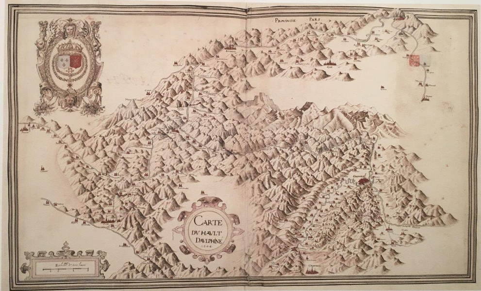
Drawn for logistical purposes, the stylized mountains of the great “Carte du hault Dauphiné” stand in contrast to the strap-worked cartouche and its surround that hollow out the picture that comprises a great piece of orography (fig. 8).
Although these drawings figure prominently in the history of cartography, they and those of other engineers of the same ilk can be shuffled into areas where poetry and landscape coincide.
For the purpose of captatio benevolentiæ, the opening paragraphs of this essay referred to the Discourse on Method. Descartes’s mention of the engineer who fancies an ideal city on a flat plain clearly betrays the accruing importance of the ingénieur du roi in the first third of the seventeenth century. In an abrupt conclusion to this overview it might be said that ruse and deception are at work in a tract that faculties call a building block of modern philosophy. It is crafted according to cartographic principles. When displaced into the context of the work of the engineers who reshape the face of the nations that employ them, it leads us in a direction where spatial planning, mapping, and the manipulations of literature are of a similar order—as well as toward different inflections of what we mean by landscape, by cartography and survey, by mapping and power, and by the ways engineering and creativity seem intimately related.
[1] I am deeply indebted to art historian Stephanie Leitsch, upon consulting the manuscript, brought the images to my attention. With bated breath we await her forthcoming book on Apian and his milieus.
Share This